Žitný ostrov – the largest river island in Europe
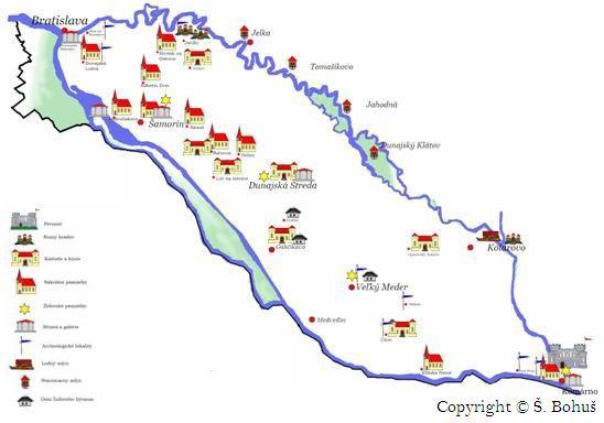
Žitný ostrov covers a length of some 84 km with a width of 15 to 30 km between the main channel of the Danube and its distributary channel the Little Danube.
The island covers more than 1600 km2 from Bratislava to Komárno. It is a part of the alluvial cone formed by the Danube downstream from Bratislava when the river cut through the Little Carpathian Mountains and entered into the subsiding Little Danube basin. Žitný ostrov is a part of the Danube plain. The youngest parts of the plain are in fact the floodplains of the individual waterways. Elevated curved mounds are found above the flat surfaces of the floodplains and are built-up structures of gravel, sand clay and even drifting sand in places.
The largest such mounds stretch over the middle of Žitný ostrov and are the oldest and driest part of the island from the perspective of morphology. These raised forms were created at an earlier period. They criss-cross the entirety of Žitný ostrov and are found along the Danube and the Little Danube. The distributary channels of the branched out river network on the tops of these elevated areas facilitated the deposition of sediments. The areas between the mounds and their lower edges were inundated with water. Some were swampy, even lake-like when water levels were high.
The Danube and its distributary channels were left wild until human activity began to alter their paths. Normally the river crept along its fertile floodplain, but every so often flood waters would strike fear into their surroundings. The largest flooding to affect Žitný ostrov occurred in 1501 when water rushed through the Danube channel at a speed of 14,000 m3/s.
Žitný ostrov – the golden garden of Slovakia
According to legend, Žitný ostrov was home to beautiful golden-haired fairies. Their queen, Tunder Ilona, swam along the Danube in the form of a swan. Her water palace impressed with both beauty and wealth. Everything sparkled with gold and gemstones. Gold dust even fell from the shoes of the fairies and into the sand. Everyone could come and pick up as much as they could carry. This is why Žitný ostrov is also referred to as the Golden Garden.
Danube sand and gravel has around 39 different minerals. Gold content is anywhere from 12 to 125 mg. While Žitný ostrov receives the lowest amount of precipitation anywhere in Slovakia (590 mm a year), water is its true treasure. There is around 10 billion m³ of high quality drinking water located under the surface that is continuously supplied by water seeping from the rivers. Žitný ostrov is a huge supply of ground water.Ground water depths range from 1.52 m to 6.7 m below the surface on Žitný ostrov. Žitný ostrov is one of the highest-yield agricultural areas in Slovakia. The soil in the west where ground water is sufficiently low is fertile, black earth. The soil around this area is brown earth. Ox-bow lakes are filled in by peat soil. Salt marshes can also be found in areas. Mollic fluvial soils are prevalent along the Danube and the Little Danube where they overflow their banks to a significant width.
